Avalanche forecasting is an intricate science, demanding a comprehensive understanding of a multitude of variables that influence snowpack stability and the potential for avalanches. In the pursuit of more accurate predictions and timely warnings, various methods have been employed for avalanche detection. While some techniques, like aerial and satellite sensors, offer precision in mapping avalanches’ spatial distribution, they present challenges when applied to real-time forecasting. Similarly, seismic techniques hold promise but bring their own complexities when integrated into forecasting systems. However, amidst these methods, one emerges as a game-changer: real-time temperature and snowpack monitoring. This article delves into the critical role of this technology in enhancing avalanche forecasting accuracy and ensuring the safety of backcountry users.
Aerial and Satellite Sensors: Precision vs. Real-Time Challenges
Aerial and satellite sensors have revolutionized the field of avalanche detection by providing unparalleled precision in mapping the spatial distribution of avalanches. These technologies offer detailed, high-resolution imagery that aids in identifying potential avalanche-prone areas (Kapper, et.al, 2023). However, the key challenge lies in harnessing this precision for real-time forecasting. While the data collected is invaluable for post-incident analysis and research, translating it into actionable, real-time information during a storm is far from straightforward (Hafner, et. al., 2020).
The hurdles are numerous, ranging from data transmission delays to cloud cover obscuring satellite imagery. Additionally, coordinating aerial surveillance during heavy snowfall can be logistically complex and costly. As a result, while these sensors excel in delivering precise information, their application in real-time forecasting remains limited (Hafner, et. al., 2020).
Seismic Techniques: Promising yet Complex
Seismic techniques have emerged as a promising avenue for avalanche detection, offering unique insights into the dynamics of snowpack instability. These methods capitalize on the seismic energy generated by avalanches, which produces distinct signals that can be detected and analyzed (Heck, et. al., 2018). The promise of seismic techniques lies in their potential to provide early warnings of avalanche activity, offering a valuable layer of safety for backcountry enthusiasts.
However, the path to integrating seismic methods into real-time avalanche forecasting is far from straightforward. Seismic sensors require precise placement and calibration to accurately capture avalanche signals amidst background noise. Additionally, distinguishing between various seismic sources, such as avalanches, earthquakes, or even human activities, presents a significant challenge (van Herwijnen and Schweizer, 2011). The complexity of seismic data interpretation, coupled with the need for a robust real-time infrastructure, makes the seamless integration of seismic techniques a work in progress.
Visual Insight: Cameras in Avalanche Forecasting
High-resolution cameras play a vital role in avalanche monitoring and forecasting by offering real-time visual data of avalanche-prone slopes. Their continuous observation capabilities provide critical insights, allowing forecasters to detect and assess avalanche activity as it happens (Veilleux, et. al, 2021). This visual confirmation not only aids in assessing the size and impact of avalanches but also helps evaluate potential dangers to infrastructure, transportation routes, and backcountry users. Moreover, high-resolution cameras are a cost-effective solution for avalanche monitoring, offering an affordable way to maintain continuous surveillance .
However, the effectiveness of these cameras depends on factors such as line-of-sight visibility, which can be obstructed by vegetation, snow accumulation, or fog. Regular maintenance is essential to keep the cameras operational, involving tasks like clearing snow and ice from lenses and checking power sources. Additionally, careful placement of cameras is crucial to maximize their utility in avalanche forecasting. When integrated into a broader avalanche monitoring system alongside other observation methods like seismic sensors and weather stations, high-resolution cameras contribute to a comprehensive approach that enhances safety and improves the accuracy of avalanche predictions (Eckerstorfer, et. al., 2015).
The Game Changer: Real-Time Temperature and Snowpack Monitoring
Real-time temperature and snowpack monitoring, driven by strategically positioned sensors, revolutionizes avalanche forecasting, empowering forecasters to predict and manage avalanche risks effectively. These temperature sensors, meticulously placed in avalanche-prone areas, provide precise data on temperature gradients, snow depth, and critical parameters, enhancing forecasting accuracy (See Figure 1). Temperature gradients signal rapid temperature shifts within the snowpack, serving as crucial risk indicators (Avalanche.org). Meanwhile, real-time snow depth data aids in assessing snowpack stability (Horton and Haegeli, 2022). This precision benefits backcountry users, enabling safer route choices in avalanche-prone terrain for a secure experience.
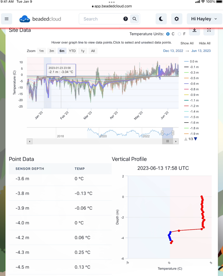
Figure 1: A snapshot from the beadedcloud Remote Monitoring Dashboard
This figure illustrates a six-month dataset within the beadedcloud remote monitoring dashboard. It showcases real-time temperature and snowpack data, featuring point data that represents various sensor depths and a vertical profile. The vertical profile highlights surface snow gradients, mid-pack snow gradients, soil temperature fluctuations, and snow depth, providing a comprehensive view of the monitored site.
Monitoring the snowpack temperature profile yields valuable insights, including near-surface and mid-pack snow gradients, springtime changes, soil temperature fluctuations, near-surface air gradients, and more—integral for comprehensive avalanche forecasting and safety (Wagner, 2013).
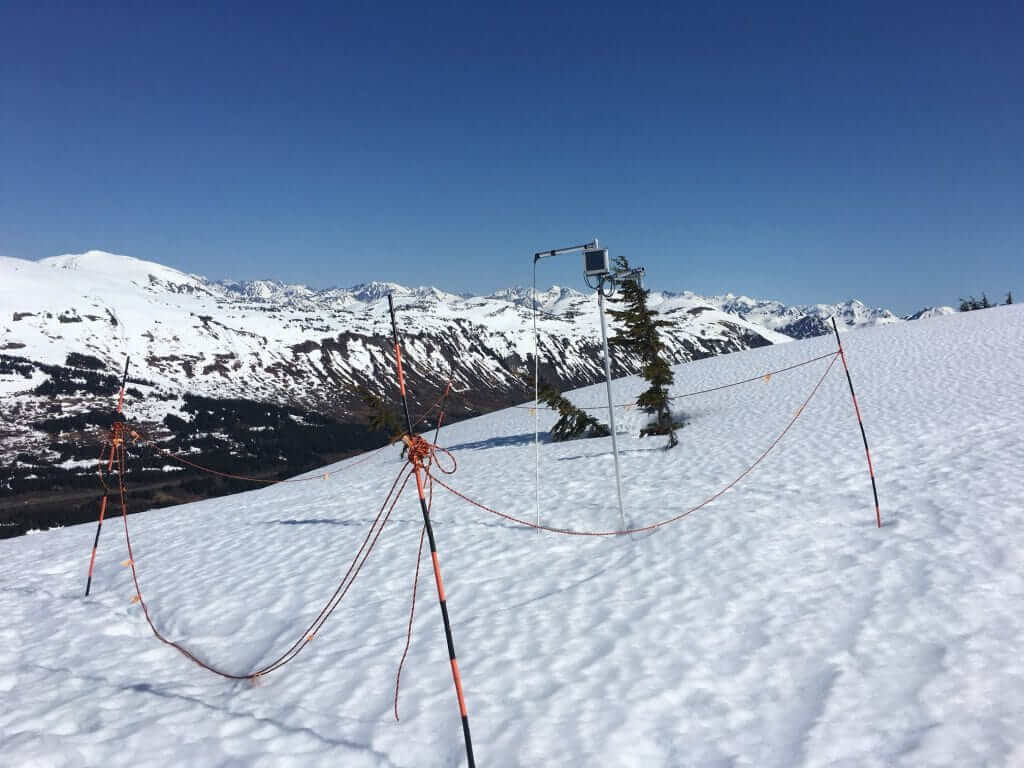
beadedstream’s Temperature and Snowpack Monitoring System in Chugach National Forest Avalanche Information Center amplifies avalanche forecasting. Utilizing Digital Temperature Cables with closely spaced sensors suspended above the snowpack, it offers real-time insights. The temperature sensors are seamlessly integrated with a satellite telemetry data logger, providing regular data transmissions every 2 hours to the beadedcloud platform, a comprehensive temperature monitoring data dashboard. The beadedcloud dashboard boasts a user-friendly API, enabling seamless data integration with other platforms, which can be immensely beneficial to a wide range of users. Its compact, lightweight design allows easy transport and installation, even in remote areas that require helicopter access. This tool empowers forecasters with immediate, site-specific data, improving assessments, temperature interpretations, and avalanche forecasts. beadedstream’s snowpack and temperature monitoring system is more than a technology; it’s a vital tool, enhancing avalanche risk prediction and safeguarding backcountry enthusiasts.